
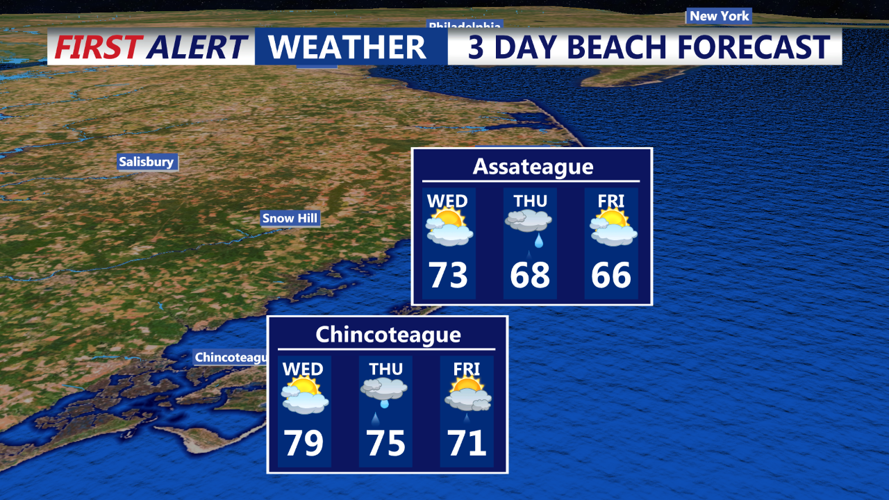


DELMARVA - Wednesday: Morning showers and a possible thunderstorm will clear out early, followed by decreasing clouds and rising temperatures in the afternoon. Expect the warmest day of the week, with highs from the upper 70s in the north and west to the mid to upper 80s in the south, away from cooler waters. Conditions will be breezy, with south winds gusting over 20 mph. Isolated afternoon showers or storms are possible, but the day will largely remain dry.
Wednesday Night Through Friday: The weather remains active as one low pressure system moves out to sea east of New England Wednesday night, and another approaches from the midwestern states. This will push a warm front towards the area by Thursday morning, potentially bringing showers and storms starting around sunrise here in Delmarva.
Thursday will be unsettled with widespread showers and storms as the next low pressure system moves across the region. However, there's significant uncertainty regarding the system's track, affecting both temperatures and severe weather potential. Current models suggest the low will track eastward near Delmarva, limiting northward progression of the warm front and concentrating severe weather threats in Delmarva, where the Storm Prediction Center indicates Marginal to Slight Risk of severe weather. Highs on Thursday are expected to vary from the upper 60s/low 70s in the north to mid/upper 70s in the south, dependent on the system's track. Showers and storms may persist through much of Thursday night, although the severe weather threat should diminish overnight due to the loss of daytime heating.