
Latest Weather

  • Updated

Near record highs today, then a First Alert day Thursday for the possibility of severe weather. First Alert Meteorologist Bob Trihy has an update.

First Alert Thursday for severe weather potential

severe potential on thursday

Severe storms possible on Thursday for Delmarva.

DELMARVA-  We're seeing near record warmth heading into the afternoon with temperatures soaring into the mid to upper 80s. We will come close to a record in Georgetown. The current record high is 90 from 2000, with a projected high around 88 degrees. Skies will be mostly cloudy to partly cloudy through the afternoon, with cooler 70s at the beaches. 

Overnight we'll see variable clouds and mild conditions with lows in the low to low mid 60s. Feeling warmer with the muggy conditions. Light SW winds are expected.

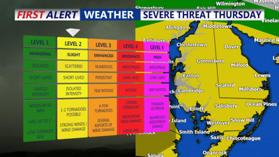
For Thursday, a Code Red has been issued for the potential of hail and damaging winds as a stronger front will trigger showers and thunderstorms. Make sure outdoor items are secured or brought inside, in case of damaging winds. High temperatures occur late morning or early afternoon, then falling into the 60s then 50s. Thursday night the rain ends with partial clearing, lows in the mid 50s.

Friday will be cooler with still a chance of some showers. Highs will only be in the mid 60s. Showers end Friday night will lows in the upper 40s to near 50.

The weekend looks 50/50 with dry and cool weather Saturday then showers on Sunday. Highs in the 60s, and lows near 50 Sunday morning.

Milton, DE

Right Now
88°
Partly Cloudy
  • Humidity: 42%
  • Feels Like: 89°
  • Heat Index: 89°
  • Wind: 12 mph
  • Wind Chill: 88°
  • UV Index: 6 High
  • Sunrise: 05:55:09 AM
  • Sunset: 08:00:48 PM
  • Dew Point: 62°
  • Visibility: 10 mi

Today

Partly cloudy. High 88F. Winds W at 10 to 20 mph.

Tonight

Partly cloudy. Slight chance of a rain shower. Low 62F. Winds light and variable.

Tomorrow

Rain showers in the morning with scattered thunderstorms arriving in the afternoon. A few storms may be severe. High 69F. Winds E at 10 to 15 mph. Chance of rain 50%.

Next 12 Hours

Time
Temp
Precip
3 PM
88°
1%
3 PM
88°

Wind: W @ 13 mph

Precip: 1% Chance

Humidity: 42%

Wind Chill: 88°

Heat Index: 89°

UV Index: 6 High

Visibility: 10 mi

4 PM
88°
3%
4 PM
88°

Wind: W @ 14 mph

Precip: 3% Chance

Humidity: 40%

Wind Chill: 88°

Heat Index: 89°

UV Index: 4 Moderate

Visibility: 10 mi

5 PM
87°
24%
5 PM
87°

Wind: W @ 12 mph

Precip: 24% Chance

Humidity: 38%

Wind Chill: 87°

Heat Index: 88°

UV Index: 2 Low

Visibility: 10 mi

6 PM
84°
12%
6 PM
84°

Wind: W @ 10 mph

Precip: 12% Chance

Humidity: 41%

Wind Chill: 84°

Heat Index: 84°

UV Index: 1 Low

Visibility: 10 mi

7 PM
82°
1%
7 PM
82°

Wind: W @ 5 mph

Precip: 1% Chance

Humidity: 47%

Wind Chill: 82°

Heat Index: 84°

UV Index: 0 Low

Visibility: 10 mi

8 PM
78°
2%
8 PM
78°

Wind: WSW @ 4 mph

Precip: 2% Chance

Humidity: 56%

Wind Chill: 78°

Heat Index: 81°

UV Index: 0 Low

Visibility: 10 mi

9 PM
75°
2%
9 PM
75°

Wind: WSW @ 3 mph

Precip: 2% Chance

Humidity: 63%

Wind Chill: 75°

Heat Index: 75°

UV Index: 0 Low

Visibility: 10 mi

10 PM
73°
15%
10 PM
73°

Wind: WSW @ 3 mph

Precip: 15% Chance

Humidity: 69%

Wind Chill: 73°

Heat Index: 73°

UV Index: 0 Low

Visibility: 10 mi

11 PM
71°
15%
11 PM
71°

Wind: W @ 3 mph

Precip: 15% Chance

Humidity: 72%

Wind Chill: 71°

Heat Index: 71°

UV Index: 0 Low

Visibility: 10 mi

12 AM
70°
15%
12 AM
70°

Wind: W @ 3 mph

Precip: 15% Chance

Humidity: 74%

Wind Chill: 70°

Heat Index: 70°

UV Index: 0 Low

Visibility: 10 mi

1 AM
68°
15%
1 AM
68°

Wind: WNW @ 2 mph

Precip: 15% Chance

Humidity: 76%

Wind Chill: 68°

Heat Index: 68°

UV Index: 0 Low

Visibility: 10 mi

2 AM
67°
15%
2 AM
67°

Wind: WNW @ 1 mph

Precip: 15% Chance

Humidity: 78%

Wind Chill: 67°

Heat Index: 67°

UV Index: 0 Low

Visibility: 10 mi