


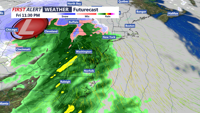


DELMARVA - Another storm is on the way to the coast to end the week. A powerful storm moving into the Midwest will have far-reaching impacts. Heavy rain, strong winds, and some coastal problems are expected Friday evening through early Saturday morning.
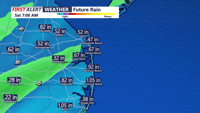
The timing of the rain is between 7 p.m. Friday evening through 5 a.m. Saturday morning. During that time, we are expecting showers and heavier bands of rain to pass through the region. Rainfall totals between 0.5”-1” are expected as this storm moves through. While these totals would not usually cause problems, due to recent rain we will likely see ponding of water on roadways, in yards, and in farm fields.

Rainfall totals between 0.5"-1" are expected across the area Friday night.
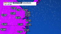
Winds will be a problem with Friday nights storm. Winds are not expected to gust as high as 70 to 80 miles per hour, like they did with the storm earlier in the week. That being said, we are still looking at the potential for wind gusts between 50 to 60 miles per hour. Winds in this range will be capable of bringing trees down and some power lines down, especially with the saturated ground. Power outages will be possible. Be sure to tie down or bring in any lightweight and loose objects that can be blown around. Winds will remain gusty on Saturday as chillier air returns to the coast.

Wind gusts between 50-60 miles per hour are expected Friday night.
Coastal flooding will return for Friday evenings high tide along the Atlantic and Delaware Bay facing beaches along with the back bays. The flooding will return to the Chesapeake Bay and its tributaries for both high tides on Saturday. On the beaches, we are looking at minor coastal flooding. The back bays, including Rehoboth Bay, Indian River Bay, Little Assawoman Bay, the Assawoman Bay, and the Sinepuxent Bay, can expect to see minor to moderate coastal flooding Friday night. On the Chesapeake Bay and its tributaries we are looking at moderate to major coastal flooding.
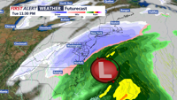
Once this storm passes, the big weather story will turn to the Arctic air and potential snow on the way next week. At this time, we are expecting several days next week to feature highs in the low to mid 30s. Overnight lows will tumble into the teens and twenties. Tuesday will be the day to watch for some wintry weather. A developing area of low pressure will slide off the coast to our south. Depending on the exact track of this storm, Delmarva could see its first accumulating snow of the season.

A storm could bring Delmarva its first accumulating snow early next week.
Be sure to stay tuned to CoastTV or download the CoastTV weather app for the latest weather forecast.